搜索结果: 1-15 共查到“工学 Geoscience”相关记录17条 . 查询时间(0.061 秒)

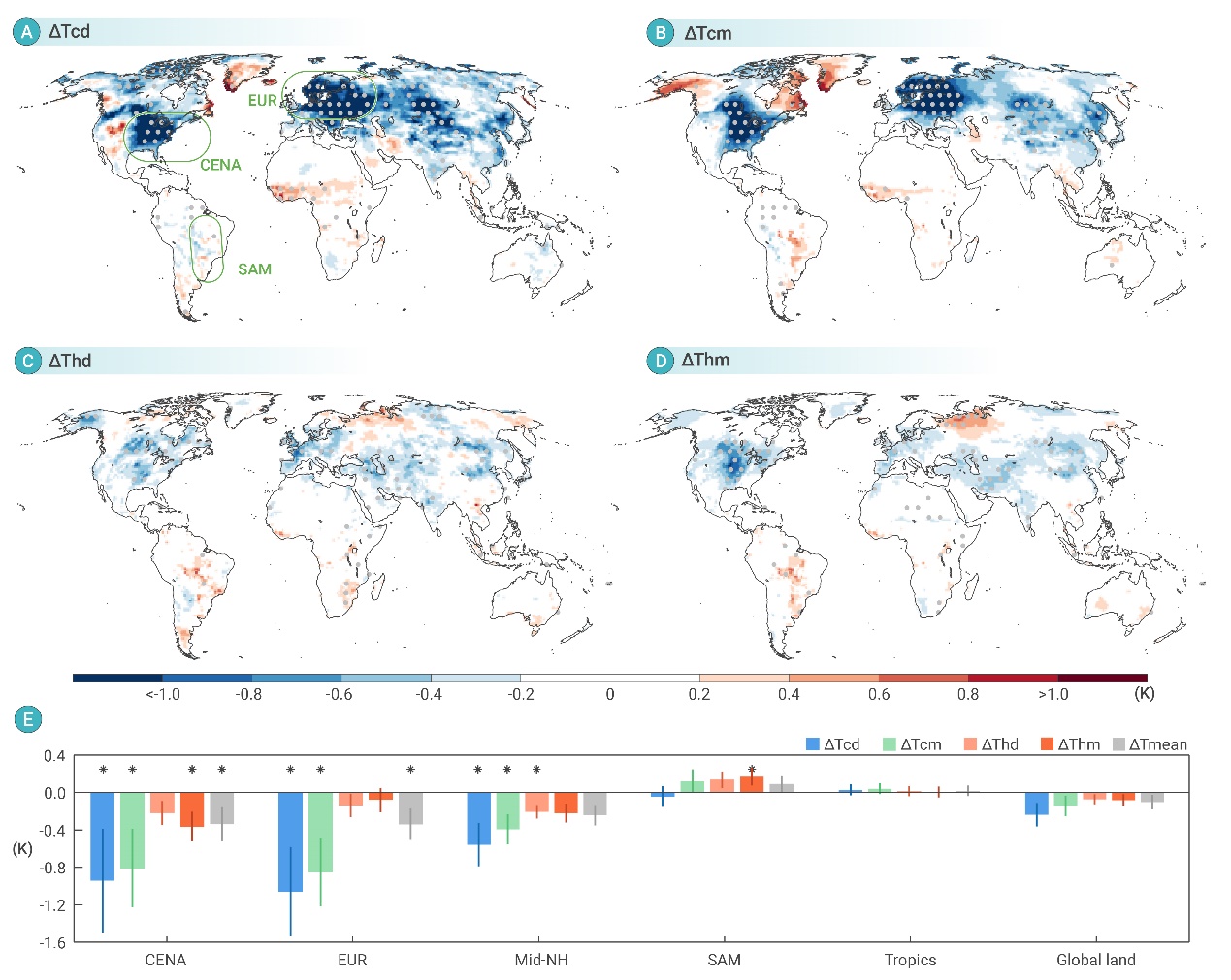
地表植被变化对气候有着重要的影响,过去的研究要么关注平均温度,要么只关注直接作用(由反照率,蒸发散和粗糙度的变化直接导致的温度变化)而忽略气候反馈带来的间接作用。因此我们利用耦合的气候模式研究自1850年以来的植被变化导致的极端天气,我们的结果不仅包含了直接作用,还包含过去通常被忽略的间接作用
郑州大学电气与信息工程学院“计算智能与优化控制”科研团队在国际权威期刊《IEEETransactions on Geoscience and Remote Sensing》发表多项研究成果
计算智能 优化控制 红外弱小目标检测
2024/9/6
雷速共建数据
近日,郑州大学电气与信息工程学院梁静教授带领的“计算智能与优化控制”科研团队联合香港大学与腾讯公司在红外弱小目标检测领域取得多项成果。

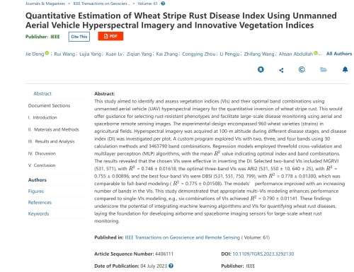
中国农业大学植物保护学院马占鸿教授团队在IEEE Transactions on Geoscience and Remote Sensing发表研究成果(图)
马占鸿 IEEE Transactions on Geoscience and Remote Sensing 小麦条锈病 遥感
2023/12/11

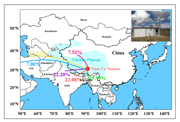
GEOSCIENCE FRONTIERS:揭示青藏高原内陆大气污染物受印度季风及平流层入侵影响的不同机制(图)
中国科学院西北生态环境资源研究院 GEOSCIENCE FRONTIERS 青藏高原 大气污染物 印度季风 平流层入侵
2021/7/2
2021年7月1日,地球科学Top期刊 GEOSCIENCE FRONTIERS 发表了中国科学院西北生态环境资源研究院(简称西北研究院)冰冻圈科学国家重点实验室康世昌研究员团队与中科院青藏高原研究所、中国环境规划院、美国Saint Louis University、德国Institute for Advanced Sustainability Studies等单位合作研究成果,并以 Impact...

GEOSCIENCE FRONTIERS:揭示中国西南地区大气污染物浓度水平、时空变化及受跨境传输的影响(图)
中国科学院西北生态环境资源研究院 GEOSCIENCE FRONTIERS 大气污染物
2021/6/11
2021年6月8日,地球科学top期刊 GEOSCIENCE FRONTIERS 发表了中国科学院西北生态环境资源研究院(简称西北研究院)冰冻圈科学国家重点实验室研究团队与中科院青藏高原研究所、云南大学、美国Saint Louis University、德国 Institute for Advanced Sustainability Studies 等单位合作研究成果Influence of tr...

近日,Nature Geoscience杂志在线发表了兰州大学资源环境学院西部环境教育部重点实验室聂军胜课题组关于澜沧江形成时代和驱动机制的论文。论文题目为“Rapid incision of the Mekong River in the middle Miocene linked to monsoonal precipitation”。澜沧江是世界十大河流之一,发源于我国青海省、流经老挝、缅甸...
2017 IEEE国际地球科学与遥感研讨会(2017 IEEE International Geoscience and Remote Sensing Symposium)
2017 IEEE 国际地球科学与遥感 研讨会
2017/7/18
We are less than 2 months away from IGARSS 2017, and the conference is shaping up nicely. Our technical program is set and available for review, and we look forward to welcoming our speakers, paper au...

中国地质大学(北京)国际地学期刊《Geoscience Frontiers》2016年影响因子高达4.256(图)
中国地质大学(北京) 国际地学期刊 Geoscience Frontiers 2016年 影响因子 高达4.256
2017/7/13
日前,科睿唯安(原汤森路透知识产权与科技事业部)公布了2016版《期刊引证报告》,由中国地质大学(北京)和北京大学共同主办的国际地学期刊《Geoscience Frontier》(简称GSF)获得首个影响因子,高达4.256,在国际综合地学类188种期刊中排名第13,位居前列(Q1区)。这标志着GSF已经成功进入国际优秀地学综合类期刊行列。
2017SPIE地球科学与遥感中的高性能计算专题会议(High-Performance Computing in Geoscience and Remote Sensing)
2017 SPIE 地球科学与遥感中的高性能计算 专题会议
2017/4/26
Advances in sensor technology with higher spatial, spectral and temporal resolutions are revolutionizing the way remote sensing data are collected, managed and processed. Latest-generation instruments...
2017年IEEE国际地球科学与遥感大会(2017 IEEE International Geoscience and Remote Sensing Symposium)
2017年 IEEE国际地球科学与遥感 大会
2017/3/10
We are pleased to host this exciting conference. We expect nearly 2,000 attendees from around the world, and our invited speakers, networking events and technical sessions offer something for everyone...
We are delighted to announce that the 2nd Virtual Geoscience Conference (VGC) will be held in Bergen, Norway, 22-23 September 2016. The conference theme is all about multidisciplinary collaboration, a...
EVALUATION OF GEOSCIENCE LASER ALTIMETER SYSTEM (GLAS) WAVEFORMS FOR VEGETATED LANDSCAPES USING AIRBORNE LASER ALTIMETER SCANNING DATA
LIDAR laser altimetry laser waveform analysis waveform simulations topography vegetation
2015/3/10
The Geoscience Laser Altimeter System aboard NASA’s Ice, Cloud and land Elevation Satellite will record the height distribution of laser energy reflected from surfaces within 70 m diameter footprints....

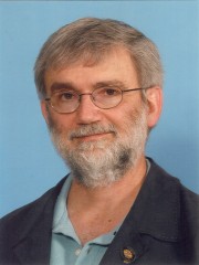
Professor Gary Frank Margrave,Department of Geoscience is a vibrant cornerstone of the University of Calgary(图)
Professor Gary Frank Margrave Department of Geoscience is a vibrant cornerstone of the University of Calgary Multidimensional Data Analysis and Processing
2014/4/16


Professor Laurence Robert Bentley,Department of Geoscience is a vibrant cornerstone of the University of Calgary(图)
Professor Laurence Robert Bentley Department of Geoscience is a vibrant cornerstone of the University of Calgary Groundwater Flow & Transport Modeling
2014/4/16


