搜索结果: 1-15 共查到“地球物理学 geology”相关记录18条 . 查询时间(0.015 秒)

板块重构研究表明,侏罗纪以来北半球逐渐形成了以欧亚大陆东部为代表的长期板块汇聚中心,表现为西伯利亚、蒙古、印度、阿拉伯等地块群以及(古)特提斯、(古)太平洋板块向该区域的汇聚。此外,该阶段(重)新启动的单向俯冲过程也大多是朝欧亚大陆东部发起的。从定性的角度来看,似乎有“黑洞”似的结构长期位于欧亚大陆东部的下方,并将周边的板块吸引到自身之下,加剧板块间的挤压。然而,现有模型较难解释北半球至少200 ...
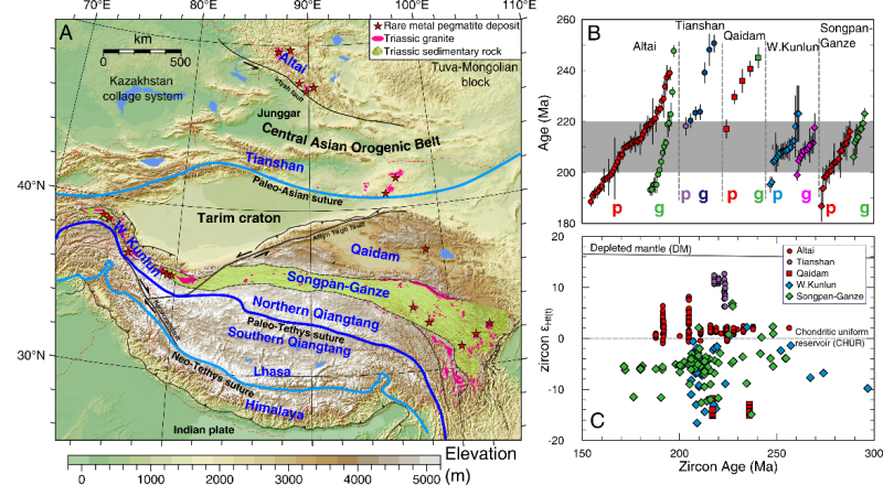
伟晶岩型矿床是锂、铍、铌、钽等稀有金属矿产的重要来源。但目前伟晶岩的岩石成因、稀有金属富集机制和矿床形成的动力学背景仍然不清楚。针对上述科学问题,中国科学院广州地球化学研究所、深地科学卓越创新中心唐功建研究员、王强研究员、但卫副研究员、马林研究员、杨亚楠博士及合作者对亚洲大陆的西昆仑-松潘甘孜,以及中亚造山带的阿尔泰等地的花岗伟晶岩稀有金属矿床进行了综合研究。该研究发现这些稀有金属矿床的花岗岩、伟...
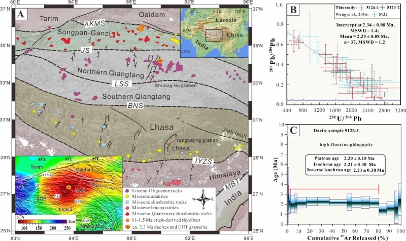
热能够促进地壳发生熔融分异、元素迁移,并且能控制线性造山带向平坦高原演化,但导致大陆地壳增温的动力学机制仍存在激烈争论。近年来,随着超高温变质作用(温度 > 900 °C,压力 = 0.7–1.3 Gpa)记录的不断被发现,人们认识到大陆地壳在演化过程中可以达到极端的地温梯度。因此,超高温变质记录被认为是解开地壳热演化机制之谜的钥匙。
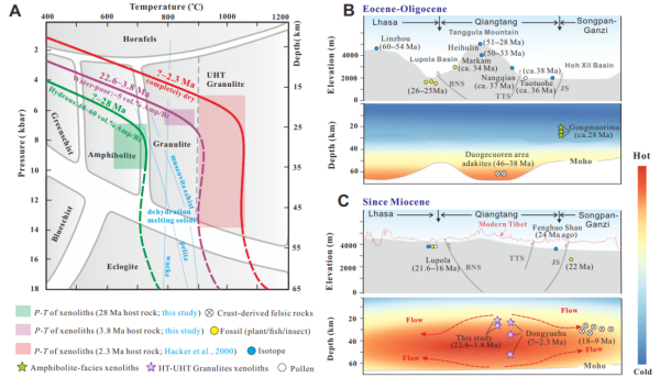
青藏高原是世界上最大、最高的高原,其形成和演化改变了亚洲地貌和水系,影响全球气候环境变化。因此,其隆升历史和机制一直是地球科学研究的热点之一。青藏高原具有2大突出特征,一是高的海拔,二是异常平坦的地貌(图1)。虽然目前对于高原局部隆升以及地壳增厚研究已积累了大量资料,但对于高原平坦化的深部机制却鲜有研究。由于自始新世以来,高原内部的剥蚀速率极低,因此理论和数值模拟倾向平坦高原的形成可能与深部地壳的...
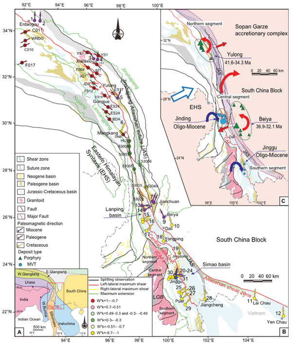
由于大尺度岩石圈构造变形和成矿作用研究长期处于彼此独立的状态,导致大型矿集区形成—就位机制一直是矿床学研究的难点,制约了大型矿集区的资源评价和勘查。青藏高原东缘是全球最典型的大陆碰撞带和复合造山带、中国最重要的有色-贵金属成矿带之一,形成了多类型的巨型矿集区,包括金沙江—哀牢山缝合带玉龙和北衙斑岩—矽卡岩型铜-金以及兰坪—思茅盆地MVT型锌-铅矿集区;前人对于这些大型矿集区的物质来源和具体成矿过程...

万博等-Geology:“海山改造型”造山作用(图)
万博 Geology 海山改造型 造山作用
2021/4/25
海山、洋岛以及洋底高原广泛分布于现代大洋,通常被认为是深源地幔柱与浅表大洋岩石圈相互作用后在洋底的不同表现形式,为了简便起见,本文用海山代表所有洋底的板内火山。统计表明现代洋底海山占全球热点总数的83%(图1)。现代大洋中最老的洋壳记录不超过2亿年,而全球联动的俯冲作用可能在20亿年前已经开始(Wan et al.,2020, Science Advances),漫长的地质历史中不计其数的洋盆关闭...
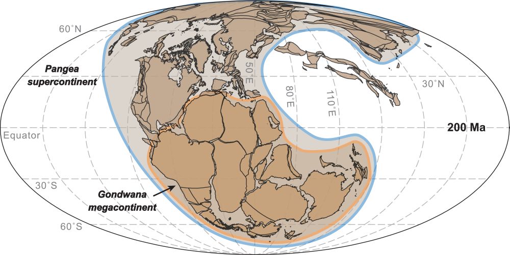
目前研究认为,过去的20亿年可能存在三个超大陆,它们分别是古元古代晚期的哥伦比亚超大陆、新元古代早期的罗迪尼亚超大陆和显生宙的潘吉亚超大陆。在新元古代,随着罗迪尼亚超大陆的裂解,一部分克拉通于5.2亿年前后在南半球形成了冈瓦纳大陆。冈瓦纳是否可称为超大陆存在争议,有学者认为它仅是潘吉亚超大陆的一部分,也有学者认为其大小和广泛的造山作用可以被视作超大陆(图1)。这一认知困惑暗示我们对超大陆的理解存在...
中国地质大学科学技术发展院张军波,刘勇胜* 等,地球科学学院. Geology, Available online 27 March 2020,Archean, highly unradiogenic lead in shallow cratonic mantle
地幔高非;放射性;铅;起源;地球;动力学
2021/10/15
近日,中国地质大学地球科学学院刘勇胜教授团队在国际地学领域顶级期刊《Geology》发表了题为《浅部克拉通地幔存在太古代高放射性成因铅》的学术论文,阐释了地幔高非放射性成因铅的起源及相应的深部地球动力学过程,建立了早元古代大氧化事件(大约23~24亿年)与地球铅同位素组成之间的重要联系。论文通讯作者为刘勇胜教授,论文第一作者为张军波博士。
自然界中铅(Pb)以四种稳定同位素存在,其中仅一种为非放...
Earth modeling and estimation of the local seismic ground motion due to site geology in complex volcanoclastic areas
dynamic amplification factor seismic tomography pyroclastic rocks finite element method
2015/9/25
Volcanic areas often show complex behaviour as far as seismic waves propagation and seismic motion at surface are concerned. In fact, the finite lateral extent of surface layers such as lava flows, bl...

Associate Professor Vedran Lekic,Department of Geology at University of Maryland(图)
Associate Professor Vedran Lekic seismology
2015/9/25
Associate Professor Vedran Lekic,At the broadest level, I seek to understand the state, dynamics, and dominant processes of the solid Earth, as well as those of other planets and satellites. Accurate ...

Professor Michael Brown,Department of Geology at University of Maryland(图)
crustal anatexis melt segregation Michael Brown Professor
2015/9/25
Professor Michael Brown,Department of Geology at University of Maryland,His Research Interests:High-T metamorphism, crustal anatexis and melt segregation, ascent and emplacement;granulites and HP/UHT ...
Geology versus myth: the Holocene evolution of the Sybaris Plain
Holocene Sybaris coastal progradation uplift subsidence
2015/9/10
Historical accounts handed down the legend of the ancient Sybaris, defeated and submerged by the Crotoniates who
diverted the River Crati on the town. This paper deals with the reconstruction of the ...
Shallow subsurface geology and Vs characteristics of sedimentary units throughout Rasht City, Iran
Shear wave velocity Vs 30 NEHRP site classification Rasht Iran
2015/8/28
The Manjil-Rudbar earthquake of June 1990 caused widespread damage to buildings in the city of Rasht located 60 km from the epicenter. Seismic surveys, including refraction P-wave, S-wave and downhole...
Geology and geophysics at the archeological park of Vulci (central Italy)
Vulci Archeological Park Geological survey Electrical resistivity tomography Magnetic susceptibility
2015/8/17
The Vulci archeological site was object of interest by the Soprintendenza ai beni culturali dell’Etruria meridionale (Italian government department responsible for southern Etruria’s cultural heritage...
A comparison of Landsat 8 (OLI) and Landsat 7 (ETM+) in mapping geology and visualising lineaments: A case study of central region Kenya
Band rationing False colour Combinations (FCC) Principal Component Analysis
2015/5/7
Availability of multispectral remote sensing data cheaply and its higher spectral resolution compared to remote sensing data with higher spatial resolution has proved valuable for geological mapping...

